Many thanks to Sue Kibby of Waste Wood for putting together this article about the archeological surveying which took place last winter.
The owners of Waste Wood and Lyn Palmer, the Historic Environment Awareness Project Officer for the Weald Forest Ridge, collaborated to develop tools for surveying woodland. The tools were used to identify sites of previous human activity. This venture was funded by the Heritage Lottery Fund and English Heritage because of the extent woodland in private ownership where all of the owners were willing to work together with Lyn’s expertise.
During the Winter of 2011 Waste Wood was surveyed from the air using Lidar. This entails technology on an aircraft which detects the variation in level of the ground. The resultant images were explained to the owners. We then walked through the woods using worksheets to record what we saw on the ground. This was a bit like an intensive crime scene search because we walked in lines and then stopped when someone observed a feature and recorded the OS reference, took photographs and completed analysis sheets.
On 7th July the owners met in Buxted reading room to receive a presentation of the findings which was given by Viviene Blandford who lives near Waste Wood and has studied the history of the area from archive material as well as helping with the on site survey. Waste Wood is near a Thirteenth Century moated site, the lost Manor of Bish when the area was owned by the Archbishop of Canterbury. Evidence of human activity goes back to 4,000 BC as evidenced by a Mesolithic Flint found in a ploughed field at the edge of the Wood. The local Wadhurst Clay is rich in iron and in one owners wood there is a Bloomery (Iron Age Iron Works).
Some of the woodland owners had also visited Lewes record office. From my own perspective this experience made me realise how little we really know about the lives of ordinary people – especially women, whose lives remained undocumented unless they broke the law or featured in a census. In the census of 1841 and 1891 a small number of families were living in the Wood.
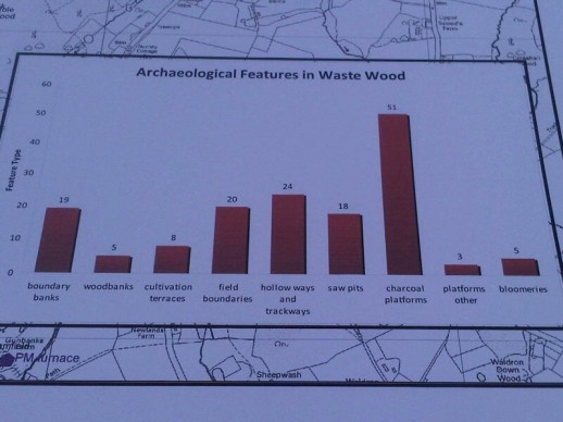
The image shows the location of the features in the Wood. These include boundary banks, woodbanks, cutilivation terraces, field boundaries, hollow paths and trackways, saw pits, charcoal platforms, other platforms and bloomeries (iron age iron works)..
Those readers who are interested can find further details at www.sewaf.org.uk and http://www.eastsussex.gov.uk/environment/archaeology/historicenvironment.htm
www.twitter.com/highweald
www.facebook.com/highwealdaonb
Sue Kibby Owner Downstream Wood
